Step 4. Check your work
First up is to compare Area I on the aerial survey map with the boundaries described in the deed from Nicholas to Henry. Here are the steps:
1. Get the pixel coordinates of the corners using the Gimp image editor, by hovering the mouse over each corner and writing down the (X Y) pixel coordinates Gimp presents.
2. Calculate the X and Y change from the beginning of each line to the end, using algebraic subtraction.
3a. Calculate the length of each line using the Pythagorean Theorem - square the X length and the Y length, add the squares and take the square root. The result is in pixels.
3b. Convert from pixels to feet - multiply by 10 (the scale of the aerial photo is 10' per pixel).
3c. Convert from feet to chains - divide by 66. Record as "length".
4. Calculate the tangent of the angle. In Trig class this was taught as Y/X, but the 0 degree line in Trig class was the X axis. In deed-speak the angle is given from true north or south, i.e. the Y axis, so use X/Y instead.
5. Calculate the angle using the arctan button of your calculator. If you don't have a calculator with an arctan button, ask your nearest High School student to borrow theirs.
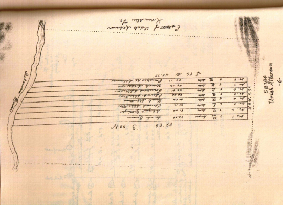
Following the deed, we'll start at point A on the overlaid aerial photo and go clockwise. The corners of Area I are located at (361 107) (646 70) (567 279) and (370 188). So line 1 runs from (361 107) to (646 70), etc.
|
Delta (X, Y)
|
Length
|
tan = X/Y
|
Angle
|
Shorthand
|
Deed
|
1
|
(285 -37)
|
43.54
|
7.7027
|
82.60
|
N82.60E 43.54
|
N82E 45.75
|
2
|
(-79 209)
|
33.85
|
0.3780
|
20.71
|
S20.71W 33.85
|
S25.75W 33.76
|
3
|
(-197 -91)
|
32.88
|
2.1648
|
65.21
|
N65.21W 32.88
|
N63.75W 32.10
|
4
|
(-9 -81)
|
12.35
|
0.1111
|
6.34
|
N6.34W 12.35
|
N3W 14
|
Regarding the shorthand, "N6.34W 12.35" translates to "face 6.34 degrees west of north, go 12.35 chains." The lengths turn out to be quite a good match between map and deed. The deed shows somewhat longer first and last lines, which is consistent with measuring along the ground, which is hilly with a steep dropoff in the northwest corner. As for the angles, the biggest deviation is in the most distinct line in the photo, "Craig's line", running down the right side of the property. I leave it to the reader to decide between the work of a local surveyor working in 1816, and your lyin' eyes.
As for Cornelius and Mary's bequest, their son Uriah died in 1799, years before either of them, but not without leaving some heirs of his own. The papers settling Cornelius and Mary's estate also settled Uriah's. There's another map in the settlement papers of 1815, and it shows something the map of Mary's whole estate fails to show - the length of Uriah's claim along the boundary with Nicholas. Run your mouse onto the map to see this dimension enlarged.
N5W 9.59. 5 degrees west of true north, 9.59 chains.
Henry's surveyor had the line running across the north end of his purchase from his father as N82E. Cornelius' heirs' surveyor had all of the parallel west-to-east lines as N86E, a difference of 4 degrees. The nearly horizontal line across the top of the photo runs N82.63E, much closer to Henry's survey. Henry had the north-south border running 3 degrees west of true north, Cornelius' heirs 5 degrees. The line running up the middle of the photo is 6.34 degrees, so that round goes to Cornelius' heirs.
There's little point in measuring the lengths of the east-west lines. They run from a river bank that is likely to have shifted some in 141 years not to mention seasonal variations, and they run up several steep inclines - mean river level to flood plain to street level up to the plateau. So let's just check the eastern boundaries of Eagle's Nest and the 2 neighboring lots against the 9.59 chains cited in the old map.
The corners on the photo-map, north to south from the NE corner of Area IV, are located at (374, 224), (381, 288), (388,350) and (395, 410).
|
Delta (X, Y)
|
Length
|
1815 Owner
|
1
|
(7, 64)
|
9.75
|
Uriah's heirs
|
2
|
(7, 62)
|
9.45
|
"Edward & heirs"
|
3
|
(7, 60)
|
9.15
|
John
|
It looks like I was a bit generous with Uriah and somewhat skimpy with John. But all in all, it looks like these lines are quite close. Close enough to find some of those old stone corners? Field trip!